


Saint Martin sur Ocre

mousetik
User
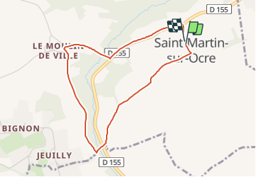

Length
3.8 km

Max alt
203 m

Uphill gradient
59 m
Km-Effort
4.6 km

Min alt
151 m

Downhill gradient
59 m
Boucle
Yes
Creation date :
2016-10-09 00:00:00.0
Updated on :
2016-10-09 00:00:00.0
1h00
Difficulty : Unknown

FREE GPS app for hiking
 SityTrail
IGN / Geographical institutes
SityTrail Plus
The world is yours!
About
Trail Walking of 3.8 km to be discovered at Bourgogne-Franche-Comté, Yonne, Le Val d'Ocre. This trail is proposed by mousetik.
Positioning
Country:
France
Region :
Bourgogne-Franche-Comté
Department/Province :
Yonne
Municipality :
Le Val d'Ocre
Location:
Unknown
Start:(Dec)
Start:(UTM)
525485 ; 5296059 (31T) N.
Comments